NOAA GEONETCast Americas

What is GEONETCast Americas?

GEONETCast Americas (GNC-A) is the Western Hemisphere component of GEONETCast, a near real time, global network of satellite-based data dissemination systems designed to distribute space-based, air-borne and in situ data, metadata and products to diverse communities.

This user-driven, user-friendly and low-cost information dissemination service aims to provide global information as a basis for sound decision-making in a number of critical areas, including Biodiversity and Ecosystem Sustainability; Disaster Resilience; Energy and Mineral Resources Management; Food Security and Sustainable Agriculture; Infrastructure and Transportation Management; Public Health Surveillance; Sustainable Urban Development and Water Resources Management. Accessing and sharing such a range of vital data will yield societal benefits through improved human health and well-being, environment management and economic growth.

GEONETCast is part of the Group on Earth Observation's contribution to the organization of the Global Earth Observing System of Systems (GEOSS) and is led by three regional infrastructure providers: EUMETSAT in Europe (EUMETCast), Chinese Meteorological Administration (CMA) in the Asia-Pacific region (CMACast), and NOAA in the Western Hemisphere.

In 2007, the U.S. National Oceanic and Atmospheric Administration (NOAA) awarded a commercial services contract to enable expansion of GEONETCast into the Americas, and the service went operational in early 2008. Today, easy to-use, low-cost receiving stations are operational throughout North, Central, and South America as well as stations in Europe.

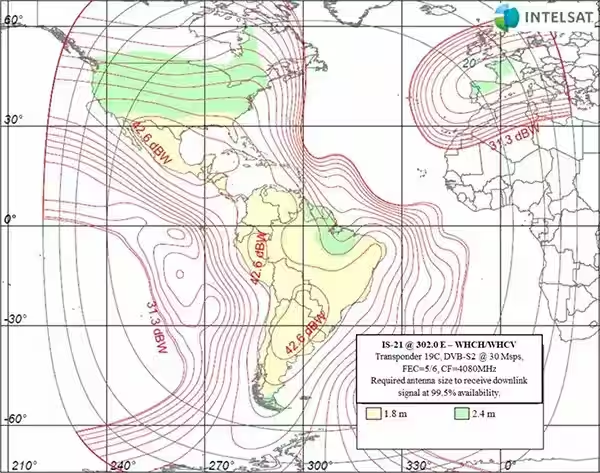
The service uses the commercial Intelsat-21 satellite to broadcast environmental and other observation data to an area covering most of North, Central, and South America. A map of the coverage area and a community graphic can be seen to the right.

slideshow
slideshow